Saturday morning, September 3rd we took off on a little trek to the top of Mt. Victoria which overlooks Wellington. It was really just a matter of going maybe 5 kilometers (3 miles) but it was our first adventure. Actually Roy Ditchburn had taken us up to the top on Thursday night and the view was fantastic so we had to return when we saw that we had beautiful weather.
Here we are with the city and port just behind us. The picture is taken looking off to the Northwest.
Here's the same shot without our interferance. You've got to agree that the view is fantastic! The greater area of Wellington has nearly 500,000 but Wellington proper is only about 200,000.
This shot is looking due North with the Wellington Bay in the foreground. The Hutt Valley is off to the left in the distance. You can see one of the four ferries that travels to the south island. The trip takes about 3 hours and costs nearly $300 one way for an auto plus five travelers.
This picture is looking off to the Southeast with the Wellington airport in the middle right of the picture. Ships coming into the Wellington port come in the channel that you can see at the base of the hills in the distance.
Very similar to the preceeding picture, this is a little more directly south showing the airport and parts of Wellington surrounding the area.
This pic is looking southwest at the southern suberbs of Wellington. The downtown city is immediately to the right of this picture. This view is of Newtown.
Here we are back looking at Wellington. Way off in the distance (west) some 60 kilometers is the south island.
From the top of Mt. Victoria the jet traffic is pretty awsome. I had to take this picture with the zoom lens. Should be turned in to the airlines marketing department don't you think.
Had to take a closer look at the airport. It is know as one of the most difficult in the world to perform a landing. The wind constantly whips over this small piece of land. Frequently the planes appear to be going sideways as they approach the runway.
On the way up to the viewing platform you pass by this 18th century cannon so you've just got to take a photo.

Here's a closer look at the city and the bay that the city sits around. It's absolutely beautiful.
When Roy took us up on Thursday night, we took a couple pictures. It's very difficult to get something that's focused very well. This was our best shot of the bay and city.
Also along the path to the top is this Maori war statue. You can see Wellington off in the background.
Here's a closer picture of the ferry coming into port from the South Island. This scene repeats itself about 8 times daily with two ferry companies having 2 ferries each.
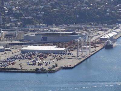
The USA plays Australia in the Wellington Stadium in World Cup Rugby on Friday the 23rd of September. We look out on the stadium from our workplace lunchroom (tearoom as it's known in New Zealand).


Wow~ it's too bad you have to serve in such ugly surroundings! Wellington is beautiful and it looks like you are having the opportunity to get out of the office once in a while to enjoy the outdoors. But here's the real question....how is the food?
ReplyDelete